
Travel Itineraries
The Turtle Rocks Oceanfront Inn provides the ideal lodging location for exploring the magnificent redwoods, the spectacular beaches and lagoons, and the surrounding towns of McKinleyville, Arcata and Eureka to the south and Orick to the north, each with its own unique charm. We love to help our guests find exciting things to do around Humboldt County and the Redwood Coast. Here are a few of our favorite itineraries to help get you started.
If you have only one day to explore, the Turtle Rocks Oceanfront Inn recommends this itinerary:
Exit the parking lot at Turtle Rocks Oceanfront Inn making a left turn heading north on Patrick’s Point Drive. Less than one mile (0.8 miles) on the left is the entrance to Sue-Meg State Park (formerly Patrick’s Point State Park), a magnificent 640 oceanfront acres of hiking trails to headlands and coves, and the sandy Agate Beach on the north end of the park. A whole day could be well spent here.
But with your one-day time constraint, our recommendation is to drive into the park, pay the day use fee, and head to the Wedding Rock parking area. From that area, you can quickly access the Rim Trail that goes around the relatively level bluff top of the park land. Three places in this area of the park are “must see”: (1) Wedding Rock: a huge solid-rock promontory that has a portion of its top carved out like a huge rock deck. Wonderful setting affording great views of the surrounding area including the Patrick’s Point headland to the immediate south and Mussel Rock to the north. And yes, weddings do take place from time to time here. (2) Patrick’s Point headland viewpoint just south of Wedding Rock and (3) Rocky Point just south of the Patrick’s Point headland accessed off the Rim Trail. Very dramatic settings and excellent whale-watching areas.
If you are not time-constrained, continue south on the Rim Trail and take the Abalone Point trail to a beautiful cove and then back to the Rim Trail and head south to the southern tip of the park at Palmer Point. If time is pressing, drive from the Wedding Rock parking area to the Palmer Point parking area. Short hike to a spectacular viewpoint up and down the coast: a must-see. On the north side of the Palmer Point headland is a very good trail down to the shore where harbor seals are often seen very close to the shoreline and tide pools abound.
Leaving Palmer Point, a drive to the far north of the park takes you to the Agate Beach parking area. The geology of the park changes dramatically from rocky to sandy just north of Mussel Rock and on into the Agate Beach area. Follow the well-marked and well-maintained trail down to a beautiful expansive stretch of sandy beach. You can hike north from here for miles and access the lagoon beaches, the closest being the largest lagoon called Big Lagoon.
Ceremonial Rock and Lookout Rock are special places in the park and should be seen if time permits.


The Redwood National Park has beaches as well as the largest surviving stands of the old-growth giant redwoods. There is no fee and the park is vast and spread out. Highway 101 goes through a small town called Orick that is now home to the Redwood National Park’s offices in a beautiful new building that is the crown jewel of architecture in Orick. Orick has a myriad of wood/driftwood/burl businesses with some beautifully carved wood art by local artisans that is worth a closer look.
Just north of Orick, the only road that heads to the eastern part of the park begins. Bald Hills Road winds easterly uphill for several miles before reaching a relatively level ridgetop area and the parking area to Lady Bird Johnson Grove. This is a almost level easy walking 1.5 mile loop trail with a high concentration of giant redwoods. This is a self-guided hike with numbered posts that correspond to a brochure available to hikers at the trail head. This is a “must do” trail.
After completing the Lady Bird Johnson trail off of Bald Hills Road (a 25 minute driving trip north from the Turtle Rocks Oceanfront Inn), return west on Bald Hills Road to Highway 101. Head north on Highway 101 for two miles and turn left on Davison Road. Just a few hundred yards on this road finds you with expansive fields on each side of the road. This is the Elk Meadow of the Redwood National Park and the favorite habitat of the Roosevelt elk herds that inhabit the park lands. You are likely to see elk here. Head west another half mile on Davison Road and you reach the end of the paved road and the 8 miles of gravel road begin that end at the spectacular Fern Canyon (see “If you have two days” itinerary). Turn left at the end of the paved road onto a new paved road that quickly leads to a new area of the park being developed. New restrooms and a new large paved parking area provide a good rest stop. A paved trail leads to a beautiful large pond and the trail up to Trillium Falls (if you have more than one day).


The entire park is a revelation of awesome natural beauty. For the time-constrained, after completing the Revelation Trail, find the trail-head sign for the James Irvine Trail and hike the first half mile where you come upon a magical redwood footbridge that crosses the beautiful flowing Home Creek on its way to Fern Canyon. Standing on the this old bridge carved around the old growth giant redwoods with the creek sounds and the forest canopy above is a perfect place to take a deep breath, unwind, and drink in this profound natural setting. This trail continues on 4.5 miles to Fern Canyon and is one of the most popular trails if you have more than one day.
Return to visitor center parking and exit the Prairie Creek State Redwoods Park and turn left on the Scenic Parkway and continue north. This drive is one of the great scenic drives of the West and takes you through magnificent stands of giant redwoods. Highly recommended is the Big Tree Wayside where there is a short paved trail to the “Big Tree” known for its great girth. A sign next to the tree makes for the perfect photo op.
Behind the Big Tree is a trail to the Cathedral Trees recommended for those that are not time-constrained.


After refreshing yourselves, exit the Turtle Rocks Oceanfront Inn and turn right heading south on Patrick’s Point Drive. This drive is one of the most dramatic scenic drives in the West with many turnouts along the way to enjoy the great ocean views and offshore rock formations (including Scotty Point and Whale Rock) for the first two miles and then about two miles of emerald green redwood forests. The four-mile drive from the inn south on Patrick’s Point Drive ends at a stop sign and the village of Trinidad.
Turn right at the stop sign and you will discover the Trinidad Shopping Center known also as Saunders’ Plaza on your left. Murphy’s Market is an excellent supermarket with a good deli and excellent wine and beer selections. The post office is next to the market and a very good fast food place called the Lighthouse Café is across from the market in its own separate building. We call it “gourmet fast food” (see our “Dining” reviews). Across the street from the shopping center is a Chevron gas station and mini-mart. Just west of the Chevron are two nice well-run shops called WindandSea and the Trinidad Trading Company. These two shops are very creative stores featuring work by local artisans. WindandSea has a huge selection of shells and crafts and the Trinidad Trading Company has more locally-made jewelry. Both of these special stores are worth a stop.
Heading westerly from the Trading Company and WindandSea, the Main Street turns into Trinity Street as you curve to the left and head south through the village. You pass the Trinidad Elementary School and the Town Hall and the police and fire departments. At the end of Trinity Street. you will find the Memorial Lighthouse (not a functioning one) built to honor the Trinidad fisherman that have been lost at sea. There is public parking and a stop here rewards you with a spectacular ocean and harbor view. There is a public access trail here down into Trinidad Bay and Indian Beach.


Finish your one full day in Trinidad with a dinner at the Moonstone Grill, one of the finest restaurants on the West Coast, overlooking a panoramic view of Moonstone Beach and Camel Rock.
Return to your spacious oceanfront retreat at the Turtle Rocks, relax on your room deck, and enjoy the phenomenal view. And reflect on the incredible experiences of your “one day” in Trinidad and the Redwood Coast. Create new memories at the Turtle Rocks Inn.
Note of caution: there are four short one- lane stretches of road on Scenic Drive beginning one mile south of the village of Trinidad. Not recommended at night or during any adverse weather conditions.
If you have two days, suggested things to do:
With a second full day to explore, Fern Canyon and the Tall Trees Grove are “must sees” .
Exit left from the Turtle Rocks Oceanfront Inn parking area and go north on Patrick’s Point Drive two miles where you intersect Highway 101. Then head north on Highway 101 and go to the Redwood National Park visitor center just north and west of Freshwater Lagoon and the ocean just south of the town of Orick. This a left turn off the highway. To hike the Tall Trees you need a permit from the park rangers. There is no charge for this and the rangers will give you either a key or combination to the locked gate access to the last road into the grove.
For this writing, I have arbitrarily chosen Fern Canyon as the first destination. Go north on Highway 101 and through the town of Orick and then another three miles to the Davison Road left turn exit to Fern Canyon ( see “one-day itinerary ). Eight mile drive on Davison Road ending at Fern Canyon. At the halfway point the hilly road comes out on the Gold Bluffs beach area of the Prairie Creek Redwoods State Park. There is a small ranger pay station and a day use fee is required to complete the journey to Fern Canyon. You will encounter two shallow creek crosssings just before reaching the parking area for the canyon. No worries as the creek bottom is smooth rock and you only need to go slow in any type of vehicle as you cross.
After parking, a short hike finds you in a truly special small canyon just off the beach with water seemingly oozing and percolating from everywhere on the vertical densely- ferned canyon walls. Steven Spielberg chose this location to film most of his sequel to Jurassic Park titled “Lost World” and there is a primeval feel to this uniquely beautiful jewel of a place.


After leaving Fern Canyon , head back to Highway 101 and head south 2 miles and then go east on Bald Hills Road. This is the only main road that accesses the eastern lands of the Redwood National Park . You will pass the Lady Bird Johnson Grove (see “One day” itinerary) after a windy three miles stretch up the wooded hill. Then the road mellows out along a beautiful ridgetop as you travel another four miles to the turnoff to the Tall Trees Grove. You drive in a few hundred feet and then have to unlock the gate, drive thorugh, and lock the gate, and then proceed on a very well-maintained gravel stretch of road for a mile or so to the Tall Trees Grove parking area. The hike is 1.8 miles all downhill down a moderately steep trail that levels out at the bottom to an alluvial plain next to the large Redwood Creek . Here you find the reward for your journey: the awesome tall trees grove and the beautiful flowing creek.
Many people also miss the added bonus of the”hidden” old growth maple forest. Find it by walking along the creekbank upriver for a few hundred yards and then look for a pathway off the creekbank and into the maple grove where huge lateral branches form an incredible canopy above. This entire area (the tall trees, creek, and maples) is so amazing that you will barely notice the 1.8 miles all uphill hike back to your vehicle.
After visiting the redwoods, head back to the town of Trinidad. Highly recommended is the spectacular Trinidad Head loop trail. Exit right from the Turtle Rocks Oceanfront Inn parking lot and head south down Patrick’s Point Drive four miles. Then turn right into the village of Trinidad and turn right on Edwards Street at the Memorial Lighthouse and follow the signs to the pier and harbor. Edwards Street dead-ends at the pier. Just before reaching the pier is a parking area for Trinidad State Beach and the Trinidad Head loop trail. The first part of the trail is an uphill asphalt-paved road that affords beautiful vistas of the village and Trinidad State beach to the north. You reach a fork in the trail where the paved road trail goes left and the other part of the trail heads straight ahead and uphill.. Go either way to do the loop and you will be rewarded with amazing ocean and mountain views and lush coastal vegetation all along the hike. Allow a minimum of one hour to complete the hike. There are benches in strategic view locations along the loop to sit and enjoy the incredible scenery.


Just west of the marine laboratory parking lot is a wonderful view overlooking Trinidad State Beach. A trail here heads north and connects to the Mill Creek trail that heads down along the beautiful lush Mill Creek canyon and on into the north end of Trinidad State Beach. Another recommended hike if time permits.
The Trinidad area and the greater Redwood Coast offer seemingly endless special things to do. One could spend weeks doing only nature hikes and still not do all of them. Here are a few more of our favorite things to do north of the Turtle Rocks:
Far north redwoods excursion: exit Turtle Rocks parking lot turn left and head north on Patrick’s Point Drive two miles and intersect Highway 101 and go north. Continue on 101 through Orick and across the magnificent Klamath River (second largest river in California). This is an approximately 40-minute drive north of the Turtle Rocks Oceanfront Inn. A few miles north of the Klamath river bridge on the west side of the highway is the Klamath Jet Boat Tours business. This is a well-run boat excursion business that this writer has enjoyed several times. The jet boat operators are very respectful of the other boats on the river and overall not much “jetting” goes on. A few fun spins in the middle of the river are done when there are no other boats nearby. The operators are naturalists with a deep respect for the river and the environment who are very good at pointing out the wildlife all around you. My favorite package is their end-of-the-day tour up the Klamath River to an off the grid house owned by the jet boat company with their own pier. A dinner is served on their large outdoor deck overlooking the river in this pristine road-less wilderness area. This dinner trip takes you the farthest up the river. Bald eagles, golden eagles, hawks and huge osprey nests are common sights along the river. If you are lucky, you may see from the boat a bear and the river minks that live along the rocky outcroppings along the river.
Leaving the Klamath Jet Boat Tours, head due west on the Requa Road. A five-minute trip that winds uphill on a well-paved road finds you back in the Redwood National Park at the Klamath River Overlook. A paved parking lot with informational park signs, the overlook is about 1200 feet above sea level and has a soaring top-of-the world sweeping view of the ocean north and south and the mouth of the Klamath River. There is a ridge-top coastal trail here affording exceptional views.


Leaving Lagoon Creek head south on Highway 101 and return to the Turtle Rocks Oceanfront Inn (about a forty-minute drive) using the Patrick’s Point Drive exit off the highway. Enjoy afternoon inn-baked desserts available on the kitchen counter from 3 pm to 8pm, fresh mostly organic fruit, organic teas, coffee, or possibly a cold beverage out of the antique Kelvinator refrigerator. Stroll the grounds, relax in your spacious room, go out on your room deck, check out the sea lions on the Turtle Rocks, offshore rocks, and enjoy the Pacific ocean waves hitting the shore… pelicans in flight, a sea lion bark echoing over the water… unwind… breathe in the sea air… listen to the ocean… you’re here… the peace and quiet of the Turtle Rocks.
And dinner on a third night, try the Sunset Restaurant (especially the seafood fettucine). Exit the Turtle Rocks parking lot, go right and head south four miles on Patrick’s Point Drive to the village of Trinidad. After the stop sign, go straight through the intersection and continue south one mile to the Cher-Ae Heights Casino (see “restaurant reviews” on this website).
Exit the Turtle Rocks parking lot, head south on Patrick’s Point Drive two miles to Seawood Drive. Go left and head east on Seawood Drive and take the south entrance to Highway 101. Go south leaving Trinidad travelling along Clam Beach to the west. About eight miles south of the Turtle Rocks, exit Clam Beach exit and drive west to a large public beach parking lot. Clam Beach is a huge sandy beach that affords a beautiful view to the north of Trinidad Head. (see “beaches” on this website) Clam Beach is in McKinleyville which is also home to an excellent 18-hole public golf course called Beau Pre. Continue south from Clam Beach on Highway 101, take the Airport Road exit, head east past the Eureka/Arcata airport (in north McKinleyville!) and go to the end of Airport Road to the stop sign. Take a right on Central and then a quick left on Norton Road and drive a quarter mile east to the Beau Pre golf course.
Leaving the Beau Pre golf course, go west on Norton Road and make a left turn and head south on Central Avenue. This is the main road through the town of McKinleyville and as you drive south you will find supermarkets, several shopping centers including a Big Kmart store and the Mill Creek Cinema theatre complex. The south end of Central Avenue has a small; hilltop area known as Bella Vista. There is an area of shops here and the excellent Six Rivers Brewery bar and restaurant that serves appetizers and dinners and has a live music venue and a really good ambience in its hilltop location.
Exiting the Six Rivers Brewery, turn left on Central Avenue and head south down the hill connecting with Highway 101 southbound. You cross the Mad River Bridge on 101 and enter Arcata. Three freeway exits south on 101 (just past the Highway 299 east interchange), exit the freeway at the main Arcata /Humboldt State University exit. You follow the road straight (you are on G Street) and it leads you into the heart of this creative vibrant university town.
Where G Street crosses 13th Street, on your left is the excellent Wildberries Market that takes up a whole city block. Very nice ambience. Lots of organic everything here with this writer’s favorite deli (great sandwiches), a juice bar, and a Ramone’s Coffee Shop serving mostly organic coffees and espressos, hot and cold beverages, and very tasty desserts made in their own bakery. There is a very nice enclosed deck with tables that have a superb view of much of Arcata and a distant view of Humboldt Bay for those who choose to eat their food there.
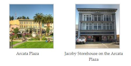
Leaving Wildberries turn left on H Street and head four blocks south to the Arcata Plaza. This is the center of the city of Arcata and is a classic town square. Find a parking spot here (which is often difficult) and get out and wander the shops and restaurants lining the plaza. The Jacoby Storehouse sits on the southwest corner of the plaza and is its predominant building. Arguably the two best restaurants in town are found in this beautifully restored historical treasure of a building. The Plaza Grill is on the second floor and has a high-ceiling with lots of windows and oak paneling. There is also a bar. Very nice atmosphere with excellent food.
In the basement of the Jacoby Storehouse is an excellent Italian restaurant called Abruzzi. Old brick interior walls and a candlelight atmosphere with only a few half basement windows create an intimate dinner house feel.
On the southeast corner of the Arcata Plaza you will find the beautifully decorated Plaza Design, a wonderful store where you can buy postcards, a wide assortment of locally-made crafts, and custom high-end furniture some of which is made by local artist craftsman.
After exploring the Plaza continue heading south on the one-way H Street four more blocks to the intersection with Samoa Boulevard. Turn right and take the first left on I Street. Head south on I Street a half-mile and you enter the Arcata Marsh and Wildlife Sanctuary. Hiking trails abound here on the north end of Arcata Bay (which is really the north end of greater Humboldt Bay). A serene place with excellent bird watching and hiking trails…

To the east of highway 101 and north is Cal Poly Humboldt (formerly Humboldt State University). This is one of the most beautiful campuses in the nation with truly special landscaping everywhere with specimen plants abounding. If you are interested in horticulture, this is highly recommended. The rhododendrons in the Spring are dazzling and brilliantly laid out in groupings of same color plants. The university’s expansive grounds back up into the Arcata Redwood Park and its network of hiking trails.
South of the university, the Baywood Golf and Country Club in the Bayside area of Arcata at the base of the redwood-studded Fickle Hill is arguably the finest overall golf course in this writer’s opinion. (check a map for directions on this). The setting is gorgeous and the weather is favorable. This is a private club but they do exchanges if you are a club member somewhere else. The Baywood is only a twenty-five minute drive from the Turtle Rocks.
Heading south from Arcata, Highway 101 wraps around the east side of Humboldt Bay. Entering Eureka, Highway 101 is now called Fourth Street. The cross streets start at the bottom of the alphabet at “Z” and go upward as you head south through the small city of Eureka. Take a right at M Street and go west two blocks to Second Street and you will see one of the finest and most ornate Victorian mansions in the United States. The Carson Mansion is now a private club and only club members and their guests may enter. But it is a sight to behold and photograph.
Eureka in general does not get the recognition for the sheer number of beautiful Victorian homes it has all over the city many of which have been lovingly restored to the original glory.
Head south down Second Street to F Street. This is the heart of the Old Town area of Eureka. A nice plaza area with a large fountain feature combine with Victorian shops to create a charming time warp feel. You may even see a horse drawn carriage here. Walk one block west on F Street to the new promenade along the bayfront. Sometimes there is live music here and there is a beautiful view across the bay to the boat harbor at the Woodley Island Marina. Getting panhandled here is also a possibility. Old Town Eureka is also the main center of the street people and homeless in the county and is home to a well-run rescue mission on the south end of Second Street near C Street
There is a little boat called the Madaket that does a trip that putts around Humboldt Bay. Between strolling the Old Town and the boat trip, several hours can be pleasantly spent here.
Southeast of the Old Town area in a nice residential area of Eureka you will find the beautifully maintained Eureka Municipal golf course. This a public golf course in a very nice setting (see a map for directions). This is only about a thirty-five minute drive from the Turtle Rocks.


The southern redwood parks of Humboldt County are much further south and also recommended as a stop on your way to San Francisco or other points south. The Avenue of the Giants has a compelling name and is a wonderful road to drive along as it roughly parallels Highway 101. The Avenue of the Giants, however, is narrow strips of old growth trees where you often can hear Highway 101 nearby and does not compare to the vast pristine expanses of the Northern Humboldt redwood parks and their amazing collection of hiking trails.
The Humboldt Redwoods State Park is large but much of it is very steep and inaccessible.
Return to the Turtle Rocks Oceanfront Inn, gaze over the Turtle Rocks sea stacks out to sea to your next door neighbor to the west (the northern islands of Japan) sip a cup of coffee or organic tea, and reflect on your third day on the Redwood Coast. Create new memories at the Turtle Rocks.